Analyzing Geofeed Technology to improve IP networks
Reading time: 3 minutes
Geofeed is a list of IP networks with basic geolocation information. It is published using CSV format through an http(s) address. Most of these addresses are shared informally between trusted parties. Some were published on sites like Reddit: Starlink has published IP Geolocation mapping.
You can have look at some Geofeeds:
- Starlink: https://geoip.starlinkisp.net/feed.csv.
- Google: https://www.gstatic.com/ipranges/cloud_geofeed
Geofeed CSV format
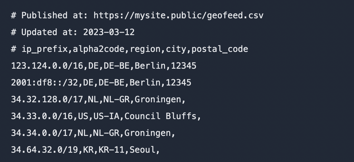
As Geofeed is published using CSV format, it can be displayed using a browser or any text editor. It consists of four values per line:
- IP network in CIDR (Classless Inter-Domain Routing) format (e.g. 192.168.1.0/24)
- Country (optional): defined using a 2-letter ISO 3166-1 country code (e.g. DE for Germany)
- Region (optional): defined using ISO 3166-2 region and country code (e.g. DE-HE for Germany and Region Hessen.
- City (optional): defined using UTF-8 encoded text. It is recommended to use an English version like Munich for German München.
Additionally to CSV data, the publisher may add information like the source of
the feed, last update, or any other information using # and adding them until
the end of the line.
An example of such a file would be (not real):
# Published at: https://mysite.public/geofeed.csv
# Updated at: 2023-03-12
# ip_prefix,alpha2code,region,city,postal_code
123.124.0.0/16,DE,DE-BE,Berlin,12345
2001:df8::/32,DE,DE-BE,Berlin,12345
34.32.128.0/17,NL,NL-GR,Groningen,
34.33.0.0/16,US,US-IA,Council Bluffs,
34.34.0.0/17,NL,NL-GR,Groningen,
34.64.32.0/19,KR,KR-11,Seoul,
Geofeed was published by Google
The idea behind Geofeeds was self-published by Google in July 2013 using draft Self-published IP Geolocation Data. After some updates in 2019 and 2020, it was published in August 2020 as RFC 8805: A Format for Self-Published IP Geolocation Feeds.
How accurate is the Geofeed information?
The information behind Geofeeds is self-published, has no right of accuracy, and as analyzed by us (beginning 2023), is mostly limited to the country information.
How many networks provide a Geofeed?
We’ve analyzed published geofeeds from different sources and can say, that geofeed is a not widespread technology. Also, most entries are country related and therefore limited in use cases.
How can this information be used?
Dependent on the project we can use this information to check, improve, or correct information related to geolocation or provider. Some of the use cases are:
- Validate and improve the deliverability of content to different networks
- Check data accuracy provided by other services and third party
- Validate or improve IP address or IP network-related data
- Value proposition calculation for providers and networks
Summary
Geofeed is a valuable technology that allows for precise geolocation of IP-based networks, down to the country level. It can be extremely helpful in enhancing communication and verifying IP-related information. However, Geofeed has some limitations that are inherent to its design, including incomplete information, uncertainty regarding the validity of the source (which is often delivered through a third-party domain such as github.com), and a lack of information about the last update. Because it is primarily used for optimizing technology usage, Geofeed is not well-known to the general public. Depending on the specific task, it may be used in combination with other sources to achieve optimal results.